|
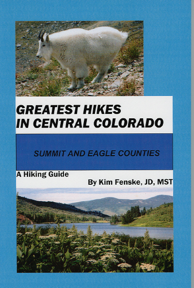
Greatest Hikes in Central Colorado: Summit and
Eagle Counties is now available for $9.99 as a magnificent, unique electronic book for download to personal computer
or reader device. A free sample of the hiking guide is available:
Hiking Colorado: Holy Cross Wilderness is
a hiking guide to the trails of the Holy Cross Wilderness Area. The book is the exclusive, authoritative guide
to the trails of Holy Cross Wilderness Area, with many scenic photographs, wildflower identifications, and topographic maps
of the area. The book is available in electronic form for download to personal computer or reader e-book devices.
The book can be purchased for $9.99. A free sample of the book with its table of contents is available at
Amazon:
Eagles Nest Wilderness Area is located in Summit and Eagle Counties of Colorado. The trails
lead to destinations in the Gore Range, including Buffalo Mountain, Rock Creek, Cataract Lake, Willow Lakes, Gore Creek,
Booth Falls, Piney Lake, South Willow Falls, Eccles Pass, Elliot Ridge, and Wheeler Lakes.
Holy Cross Wilderness Area is located in Eagle and Lake
Counties of Colorado. The trails lead to destinations in the Sawatch Range, including Nolan Lake, Lake Charles, Mystic
Island Lake, New York Mountain, Middle Lake, Beaver Lake, Turquoise Lakes, Grouse Lake, Grouse Mountain, Notch Mountain, Mount
of the Holy Cross, Tuhare Lakes, and Treasure Vault Lake.
The author of these hiking guides has years of experience hiking in the wilderness areas of Colorado.
He has maintained many of the trails featured in his books as a wilderness ranger with the United States Forest Service
and as a member of the Friends of the Eagles Nest Wilderness Area.
Below is an easy hike for beginners that is located on Buffalo Mountain between Silverthorne and Frisco that takes visitors
to Lily Pad Lakes.

Lily Pad Lake Trail
Trailhead39°37.140’ N, 106°06.630’
W
Destination 39°36.030’ N, 106°06.962’ W
Hours 1
Miles
2
Nestled among a dense lodgepole pine forest at the southeast edge of the Eagles Nest Wilderness Area, the Lily Pad
Lake Trail offers easy access to great views of the Blue River Valley surrounding Dillon Reservoir. With an elevation
gain of only 200 feet and length of 2 miles, Lily Pad Lake Trail is a welcome path for a family trek in hiking boots, snowshoes,
or cross-country skis. No mountain biking is permitted and pets should be leashed beyond the wilderness boundary.
The
trailhead begins on the eastern face of Buffalo Mountain in the Wildernest development, a few miles above Silverthorne.
In order to reach the trailhead area by public transit, hop on a Wildernest Summit Stage from the bus transfer station near
the Silverthorne Post Office, west of Highway 9 north at Third Street.
By personal vehicle, take the Silverthorne
exit from I-70 and turn left at the first intersection on Highway 9 north of the freeway. Begin traveling west along
Wildernest Road, the frontage access wrapped around the base of Buffalo Mountain. Follow the switchbacks by turning
right onto Ryan Gulch Road. Proceed through the Wildernest condominium for 3.6 miles to the shared parking pad for the
Buffalo Mountain Trail and Lily Pad Lake Trail.
The lower trailhead is the entry to the Buffalo Mountain Trail that
climbs 3,000 feet to the northwest to reach the summit of Buffalo Mountain. Up the road a hundred steps, beyond the
Summit Stage bus stop, is the gated Forest Service Road that serves as the trailhead for the Lily Pad Lake Trail.
The
Lily Pad Lake Trail, 39°37.140’ N, 106°06.630’ W, at 9,830 feet, follows the topography to the south. About
forty minutes, the Lily Pad Lake Trail meets the Salt Lick Trail, 39°36.327’ N, 106°06.815’ W, at 10,010 feet,
where the trail turns to the right and follows a water diversion ditch. The trail continues through a wetland area where
moose are frequently sighted. In a bit over an hour, the trail reaches fraternal twin ponds, Upper Lily Pad Lake
and Lower Lily Pad Lake, before descending to the Meadow Creek Trailhead near Frisco.
Upper Lily Pad Lake is a shallow
pond covered in yellow water lilies in summer and frequented by ducks. Across a small earthen berm, Lower Lily Pad Lake,
39°36.030’ N, 106°06.962’ W, provides a view of the north end of the Tenmile Range above the lodgepole forest.
To the north, the summit of Buffalo Mountain rises above the shoreline.
Beyond the beaver dam that helps close the
outlet to the lake, the trail drops through open meadows and aspen glens filled with wildflowers in summer. An alternative
adventure continues south to the junction with the Meadow Creek Trail and descends into Frisco. A short walk along a
gravel frontage road leads across the freeway overpass to the Summit Stage transfer center in Frisco, where a free bus to
Silverthorne can be found.
|